Program & Project Management
From initiation to implementation, Mountain Engineering is a full-service destination for any project needs. We serve as a liaison between clients and customers, project development and coordination with both industry professionals, the Mountain Engineering Team, and the client. Mountain Engineering Project Managers oversee and can custom design a strategy that works best with the project needs. Our Project Coordinators align the technical field services staff and implementation of training programs. Administrators work in preparation of various status reports and adherence to all industry standards for safe practices and operations.
Project Management Team effectively strategize:
- Leadership
- Scheduling
- Budgeting
- Set-up/ Layout
- Customer Outreach
- Permitting
- Implementation Bidding
- Reports
- Documentation
- Monitoring and Controlling
Geographic Information Systems (GIS)
Our skilled Geographical Information System (GIS) team offers the most up-to-date technology and data management. This enables users to collect fast, efficient, and attribute-rich geolocated data from a wide variety of mobile GPS-enabled devices. The processes used to complete this workflow provides clients with relatively no post-field hassle as well as efficiency, data consistency, and data immediacy in real-time within easily customizable and exportable formats. To help minimize user-error, all-inclusive mobile forms are developed in consortium with clients to provide the most comprehensive data collection and deliverables that uniquely fit the needs of all parties. We provide customized GIS training to support our teams’ attributes include:
- Geographical database development and support
- Metadata development and maintenance per Federal Geographic Data Committee (FGDC) standards
- Spatial record management
- PODS and other ESRI based solutions
- Analytical assessment
- Web based portals for accessing, editing and storing spatial and tabular data
- Custom mapping including map books, large and small scale maps
- Data manipulation and analysis within GIS (ArcGIS)
- Technical documentation
- Metadata development and maintenance per Federal Geographic Data Committee (FGDC) standards
- Spatial and Network analysis
- Implement data quality control and assurance (QA/QC) procedures
- Data conversion/migration and map production in accordance with mapping standards;
- Preparation of GIS data, including analysis support
- Attribute and Domain development
- Diagnosing and “troubleshooting” problems experienced with the use of GIS and related software
- Edit and create new features and feature classes
- Create and maintain scripts (Python), models, add-ins, and “toolboxes” to automate GIS processes
- Create interfaces for field data collection (Trimble TerraFlex, GIS Pro, Collector for ArcGIS) and the integration of collected data with the GIS datasets
- ESRI Platform installation/ configuration/ performance tuning, ESRI ArcGIS suite (including desktop), ArcGIS Server 10+, ArcGIS Online, Portal for ArcGIS
Environmental Planning
Mountain Engineering performs all aspects of planning, including scope development, field studies, data collection and management, reporting, multi-party negotiations, and management plan development.
- Right-of-Way (ROW) & Infrastructure Surveys
- Wildland Fire Management Planning
- Wildland Fire Prevention & Education Planning
- Community Wildfire Protection Planning (CWPP)
- Fuel Hazard Reduction Planning
- Prescribed Fire Implementation Planning
- Smoke Management Planning
- Riparian and Wetland Ecosystem Restoration Planning
- Erosion Control and Bank Stabilization Planning
- Environmental Impact Statement (EIS) Planning
- Emergency Fire Rehabilitation Planning
- Storm Water Pollution Prevention (SWPP) Planning
- Sustainable Best Management Practices (SBMP) Planning
- Historical Properties Management Plan (HPMP) Development
Land Use Planning
Mountain Engineering’s Land use planners are specialists who determine how areas of land can best be utilized to satisfy the needs of the community. We focus on planning that emphasizes the long- term sustainability of communities and how to incorporate that framework into the natural world.
- Oversee preparation of yield studies
- Understand local and state development codes and zoning regulations including CEQA and coastal development permits
- Develop conceptual site plans and land development feasibility studies
- Research regulations and compile data and maps on a variety of planning issues
- Prepare and present detailed site analysis, due diligence, and highest and best use plans, exhibits, and reports
- Provide technical assistance to BWE surveying and civil engineering staff regarding site development issues
- Prepare conceptual site plans in conformance with state, county, and local codes, plans, parking and other regulations to obtain entitlement and discretionary permits
- Communicate effectively with city and county officials, clients, and co-workers
- Make presentations to community and planning groups and at city council meetings
- Prepare proposals and expand client base
- Manage project schedules and budgets
Mitigation and Implementation
Mountain Engineering offers ecological restoration planning and implementation to minimize and offset known adverse environmental impacts through the re-establishment of structure, function, and integrity of indigenous or historic ecosystems.
- Conduct field studies that encompass all direct and indirect environmental impacts
- Determine what mitigated state is best suited for the site
- Develop site specific mitigation plans by referencing intact historical ecosystems, areas of similar synecology, and sites untouched by man
Environmental Permitting and Compliance
Mountain Engineering prepares required state and federal permits, supports licensing efforts, and performs compliance on schedule. Efforts include data collection, reporting, agency meetings and collaboration, site visits, and annual trainings.
- Federal Energy Regulatory Commission (FERC) Licensing
- National Environmental Policy Act (NEPA) Compliance
- California Environmental Quality Act (CEQA) Permitting and Compliance
- Storm Water Pollution Prevention Compliance
- Sustainable Best Management Practices Compliance
- Clean Water Act (CWA) §401, §402, and §404 Permitting
- HPMP Compliance
- State and Federal Threatened, Endangered, and Sensitive Wildlife Protection Compliance
- State and Federal Threatened, Endangered, and Sensitive Plant Species Compliance
- Environmental Training for Threatened, Endangered, and Sensitive Wildlife and Plants, and Sensitive Ecosystems
Habitat and Ecological Restoration
Natural events, land development and land use often contribute to the decline of natural habitats and interfere with ecosystem functions. Considering the irreplaceable value of our natural resources, we cooperate with clients to mitigate negative impacts to the environment and enhance ecological functions by restoring habitats. Implementing a sound and cost-effective restoration project and attending to the ecological concerns of all parties is our solution to the greater good for the environment. Our restoration services encompass, but are not limited to the following:
- Stream Channel Restoration
- Forest Thinning
- Overland Flow Reduction
- Sediment and Erosion Reduction
- Utility Access Road Construction and Habitat Restoration
Our professional services staff apply key restoration concepts and incorporate proven techniques to achieve high-quality, sustainable projects:
- Possess an understanding of natural communities and ecological functions
- Conduct soil analysis and augmentation
- Combine removal of invasive species with establishment of site-appropriate native species per best management practices
- Properly calculate seeding rate to maximize seed establishment
- Digitally reconstruct data
- Establish baseline data during the planning phase and collect data throughout and after implementation to ensure goals have been met
- Develop and implement monitoring protocol and assessment criteria
- Incorporate a variety of biological survey techniques to ensure project success
- Create restoration plans that meet regulation and environmental standards
- Work under environmental legislation
Riparian & Wetland Ecosystem Restoration
Mountain Engineering has extensive experience in design/build contract services that specializes in storm water management, erosion/sediment control BMPs, revegetation, restoration and slope/road stabilization. We frequently perform this work under demanding outdoor conditions; in response to emergencies; and in very severe weather conditions. Our QSD/QSP qualified staff knows the rules and knows BMPs; we possess the required professional training in regulatory compliance for storm water pollution planning (SWPPs), erosion/sediment control best management practices (BMPs). Using a design-build-maintain-monitor technical approach, ERT brings our clients years of field experience and cost effective installations.
Mountain Engineering helps clients manage stormwater runoff by designing and constructing first flush basins, sediment traps, and bio-swales. We stabilize soil disturbance by prescribing and applying appropriate seed mixes, stabilized hydro mulch and straw. ERT utilizes the best of the current erosion control blankets, turf reinforcement mats, straw wattles, and choir rolls. For more challenging sites subject to high stream flows or severe erosion, our construction crews install geotextile fabrics, dry-stack rock/rip-rap and gabion structures, all with native vegetative components such as willow wattles, brush mattresses, pole cuttings, and container plantings.
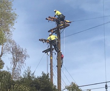
Technical Field Services
Our team of Foresters, Field Inspectors and GIS Field Data Specialists are highly trained and experienced to get your project going.
- Excellent skills and knowledge with a background of nineteen years of service within the utility business and government agencies
- All our inspectors are equipped with the most current technology to manage work and document data from the field/ office
- Data is live and can be access at any time to help you manage work progress and productivity
- All field personnel have access to continuing education opportunities including credentialed course work
- Safety culture is ingrained in our work and lifestyle
- Field Inspectors and GIS collection staff can mobilize anywhere within the US
- Customer service expertise
- Field personnel have drug testing and background screening
- Vegetation data collection is coordinated and reviewed by ISA Certified Arborists
Consulting Utility Forester
The Consulting Utility Forester is responsible for inspecting and surveying the gas distribution and/or electrical transmission right-of-way.
- Prescribe work to be removed by tree removal contractors, as well as coordinate with agencies and private property owners regarding tree trimming and tree/brush removal work.
- Required to be knowledgeable of utility regulatory requirements and utility vegetation management standards.
- Understand sylvicultural systems, timber cruising and marking principles, wood scaling principles and practices; and forestry-related equipment, such as laser rangefinders, clinometers, DBH tape, etc.
- Ability to identify local tree species (including ornamental), and some knowledge of growth rates
- Proficient computer skills, tablet/iPad skills, ability to work with computer programs and knowledge of Microsoft Office Suite; iPad GIS applications are used extensively in field work
- Able to navigate difficult forested landscapes and associated elements in remote locations in Northern and Central California
Field Inspectors
Coordinate jobs with outside services, such as subcontractors and management.
- Organize equipment, material and labor to complete project in a timely manner.
- Verify accuracy of locates, materials, and billings.
- Call in or email locates as needed.
- Complete change orders, following procedures, including passing information on to contract administrators and billing department.
- Monitor production reports.
- Support Supervisors and Foreman to monitor and enforce all company and outside required safety policies and procedures.
- Monitor and complete the necessary paperwork regarding employee accidents and injuries, in conjunction with safety.
- Maintain and properly document DOT paperwork.
- Manage materials using a spreadsheet.
- Other duties as assigned.
- Complies with all local, state, federal safety regulations, policies, and procedures.
- Audits contractors’ record-keeping practices/procedures.
- Prepare Daily Field Inspection Reports.
- Verification of work completion and acceptability for progress purposes.
- Observance of all safety and environmental procedures and safe practice.
- Perform work in accordance with company safety standards and procedures.
GIS Field Data Specialists
Our GIS Field Data Specialists(GFDS) work in the setup, maintenance, and operation of all field survey equipment, the operation of survey instruments in the field including data collectors, GPS, and other standard survey equipment. They will also prepare survey sites and remove all obstacles, including debris, brush, tree limbs, etc. GFDS work with project staff to produce maps and data relational maps using GIS software, hardware, and applications.
Emergency Response
Mountain Engineering utilizes highly trained technical specialists to assess and mitigate public safety hazards
- Property Hazard Assessments
- Industrial Hygiene Services
- Hazardous Waste Site Health and Safety
- PG&E Emergency Storm Response
- Storm Damage Tree Removal